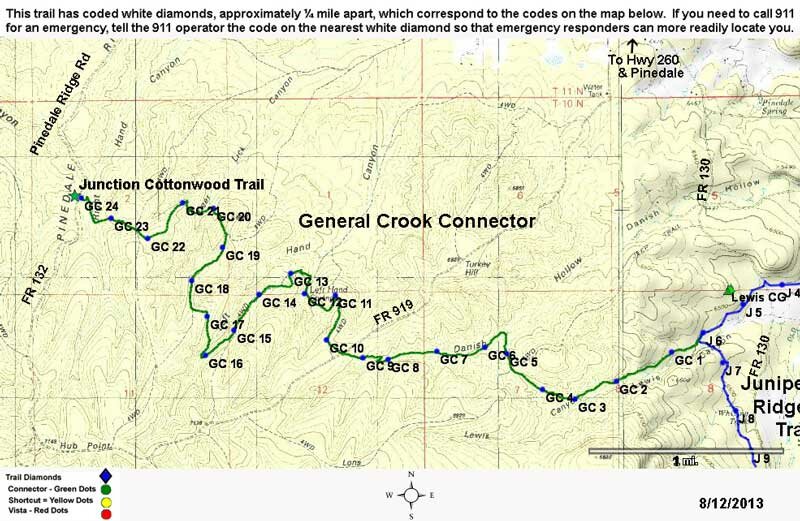
General Crook Connector #104A
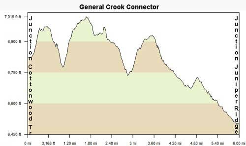
Distance: 6 miles
Difficulty: (as rated by the US Forest Service)
Hiking - Moderate
Mountain Biking - Difficult
Equestrian - Difficult
Trailhead Parking: Access from Juniper Ridge Trail.Limited, accommodates trailers
Access to Trail: From the Show Low Post Office, travel west on AZ 260 about 13 miles to Pinedale Rd. Turn left and remain on Pinedale Rd/FR 130 to the Lewis Campground turnoff. Turn right to the access to Juniper Ridge Trail. The junction with General Crook connector is about ½ mile. You can also access the West end of the trail, where it connects with the Cottonwood Trail from FR 132, about 15 miles west of Show Low.
Trail Highlights This trail takes you on a six mile hike through some of the area burned out by the Rodeo-Chediski Fire of 2002, providing fabulous views and prolific wild flowers. Due to little shade, this is a good winter or spring hike, because it is dry when others are not. This is the farthest West trail in the White Mountain Trail System. Check with the Black Mesa Ranger District regarding conditions of the Cottonwood Trail.
General Crook Connector
Printable Map
Seberapa akurat pun tebakan angka togel Anda, semua itu akan sia-sia jika kemenangan Anda tidak dibayarkan. Bersama situs togel terbaik, Bandar Togel, Anda bisa bermain dengan tenang tanpa rasa ragu atau cemas, karena kami menjamin pembayaran kemenangan secara adil dan transparan.
Bandar togel terpercaya menyediakan berbagai pilihan pasaran, termasuk Macau dan Singapore, yang merupakan dua dari pasaran paling populer di kalangan pemain Togel Online. Dengan reputasi yang sudah terbukti aman dan terpercaya, bandar togel ini memberikan kesempatan bagi pemain untuk berpartisipasi dalam pasaran dengan peluang menang yang besar. Kedua pasaran ini menawarkan variasi permainan yang menarik dengan hasil yang transparan dan cepat.
Situs agen togel internasional menawarkan jangkauan pasaran yang sangat luas, termasuk dari negara-negara besar. Dengan Togel Terpercaya, para pemain di seluruh dunia dapat memilih berbagai pasaran terbaik yang tersedia dan menikmati permainan yang aman serta transparan.
Event spesial dengan reward acak ini bikin penasaran dan daftar kemungkinan hadiahnya bisa kamu cek lewat situs toto. Update sistem hadiah bikin progres terasa lebih adil. Pemain merasa dihargai.
Selain hadiah besar, bermain di Bo Togel yang menawarkan hadiah tertinggi juga memiliki banyak keuntungan lainnya. Misalnya, situs-situs ini sering memberikan bonus tambahan seperti diskon taruhan, cashback, dan layanan pelanggan yang profesional. Artikel ini akan mengulas berbagai keuntungan yang dapat Anda nikmati ketika bermain di Bo Togel Hadiah Terbesar dengan hadiah terbesar, sehingga Anda dapat memaksimalkan pengalaman bermain Anda.
Tidak sedikit pemain yang memanfaatkan informasi dari keluaran Macau untuk bermain lebih bijak. Dengan mengetahui hasil keluaran terbaru, pemain dapat meminimalkan risiko kesalahan. Oleh karena itu, Keluaran Macau menjadi salah satu data paling dicari setiap harinya.
Dalam dunia togel, keakuratan data sangat berpengaruh terhadap hasil permainan, dan Data Macau menjadi salah satu informasi yang paling banyak dicari. Para bettor sering kali membandingkan hasil sebelumnya untuk mendapatkan prediksi terbaik. Semakin akurat data yang diperoleh, semakin besar pula kemungkinan untuk memperoleh angka jitu.
Keamanan menjadi faktor utama yang harus dipertimbangkan saat memilih Situs Togel. Situs yang baik selalu menjaga data pribadi dan transaksi para pemain dengan sistem enkripsi yang kuat, sehingga pemain dapat bermain dengan tenang.
Siaran Live draw macau menghadirkan pengalaman bermain langsung dengan menampilkan nomor yang keluar secara real-time, membuat pemain merasa lebih terlibat dan menambah ketegangan saat menunggu hasil taruhan mereka.
Bagi para pemula, memulai permainan dengan Slot Depo 5k adalah langkah yang cerdas. Ini memungkinkan mereka untuk mengenal lebih jauh tentang mekanisme permainan tanpa harus khawatir kehilangan banyak uang. Dengan pengelolaan modal yang tepat, bahkan dengan deposit kecil, pemain bisa meraih kemenangan besar.
Pengelolaan modal dan waktu bermain adalah bagian penting dari strategi di Mahjong Ways 2. Tetapkan batas taruhan harian dan beristirahat secara berkala untuk menjaga fokus. Dengan mengatur modal dan waktu dengan bijak, Anda bisa menikmati permainan lebih lama serta memperbesar peluang memenangkan jackpot gacor di slot Mahjong Ways 2.
Permainan Situs Slot Gacor online sering menghadirkan tema musiman, seperti Natal atau Halloween, yang menambah suasana dan memberikan pemain pengalaman bermain yang segar sesuai waktu tertentu.
Pemain yang ingin meraih kemenangan besar biasanya memilih RTP Slot dengan rtp slot tertinggi hari ini sebagai bagian dari strategi mereka. Dengan menggunakan rtp live, mereka bisa memantau slot gacor yang menawarkan RTP terbaik. Slot rtp tertinggi memberikan peluang menang yang lebih tinggi, sehingga sangat penting untuk selalu memperbarui informasi tentang rtp slot. Ini membantu para pemain untuk mengambil keputusan yang lebih baik dan meningkatkan peluang menang dalam permainan.
Banyak pemain yang mencari kemudahan dalam melakukan transaksi saat bermain slot online. Slot Toto menawarkan berbagai metode deposit yang praktis, mulai dari transfer bank, e-wallet, hingga pulsa. Dengan proses yang cepat dan tanpa hambatan, pemain bisa langsung menikmati permainan favorit mereka setelah melakukan deposit.
Slot 777 menyuguhkan pengalaman bermain slot yang tidak hanya seru, tetapi juga memberikan peluang besar untuk menang. Dengan menawarkan berbagai jenis permainan slot yang berkualitas, Slot 777 berhasil mencuri perhatian banyak pemain dari seluruh dunia. Fitur-fitur yang ditawarkan sangat menarik, seperti putaran gratis, bonus besar, dan jackpot yang menggiurkan.
Berbagai situs judi kini menawarkan akses mudah ke permainan melalui promo menarik bertema Slot Deposit 10k untuk menarik pemain baru.
Banyak review dari komunitas pemain menyebutkan bahwa slot gacor Thailand sering memberikan kejutan hadiah tak terduga, membuat para bettor merasa puas setiap kali mencoba keberuntungannya di permainan tersebut.
Dalam industri hiburan global, kehadiran Sbobet88 menandai era baru bagi para pemain yang menginginkan kombinasi antara keseruan taruhan dan keamanan data pribadi, menjadikannya pilihan tepat bagi mereka yang menghargai kenyamanan serta profesionalisme.
Aspek psikologis sering kali memengaruhi keputusan seseorang ketika terlibat dalam permainan angka. Di tengah euforia memasang kombinasi pilihan pada platform Toto, pemain perlu menjaga emosi agar tidak terbawa suasana. Pengendalian diri menjadi faktor penting supaya aktivitas ini tetap dalam batas wajar dan tidak memicu keputusan impulsif. Dengan sikap tenang dan rasional, pengalaman bermain terasa lebih terkendali serta terarah.
Patch kali ini fokus pada peningkatan performa biar gameplay lebih smooth, detail teknisnya lanjut ke Togel Online. Banyak tips combo skill yang bisa dipelajari dari pro player. Menonton gameplay mereka sering kasih insight baru.
Turnamen komunitas minggu ini diprediksi bakal berlangsung sengit antar guild besar, semua jadwal pertandingannya bisa kamu cek lewat info ini situs toto. Event kolaborasi kadang menghadirkan konten yang berbeda dari biasanya. Hal ini membuat game terasa lebih segar.
Promo isi ulang kali ini datang dengan hadiah tambahan yang cukup menggiurkan, rincian lengkapnya tersedia melalui Togel Online. Update balancing karakter membuat beberapa hero jadi lebih kuat. Banyak pemain langsung mencoba strategi baru.
Seiring meningkatnya aktivitas online, kehadiran Login Togel178 menjadi solusi andalan bagi pengguna yang ingin mendapatkan akses cepat, stabil, dan efisien tanpa harus menghadapi proses login yang rumit.